Author Topic: map of travels  (Read 5264 times)

0 Members and 1 Guest are viewing this topic.

Offline Jaysea

  • Soft Floor Camper User
  • ****
  • Posts: 543
  • Thanked: 31 times
  • Gender: Male
  • To go where I have never been
    • My 4WD Site
map of travels
« on: July 07, 2015, 06:12:02 PM »
I have been wanting to put together a map of all the road trips we have done.  I have played around with google map but its limitation is that you can only have a maximum of 8 different routes on the one map (unless i am doing something wrong).  I have looked at a couple of others but they only go point to point (like a plane) not following the road.  any one got any ideas or options.

Thanks
Jaysea

2012 Prado GXL + Adventure Camper

My build: http://www.myswag.org/index.php?topic=17776.0
My photos & travels: www.lensontheroad.com
My facebook: http://tinyurl.com/k2haolg


Offline Spada

  • Hard Top Camper User
  • ******
  • Posts: 2285
  • Thanked: 481 times
  • Gender: Male
Re: map of travels
« Reply #1 on: July 07, 2015, 07:16:27 PM »
Its primitive, but I have a laminated Hema map of Australia in the pool room. I just use different colour paint pens to colour in the trip.

But for the trip video's I do, I download a high res map as a picture, and use Microsoft paint to draw in the trip.
Spada.
76 Series Cruiser & Zone Peregrine caravan.

Offline BTMNDR

  • Tent User
  • ***
  • Posts: 116
  • Thanked: 5 times
  • Gender: Male
Re: map of travels
« Reply #2 on: July 07, 2015, 09:04:16 PM »
Have a look at inRoute in the Apple (iOS) App Store.
Former TOPNDR.

Offline PenUltimate Destinations

  • Soft Floor Camper User
  • ****
  • Posts: 277
  • Thanked: 11 times
  • Gender: Male
    • PenUltimate Destinations
Re: map of travels
« Reply #3 on: July 07, 2015, 09:36:47 PM »
Could always use something like the Hema explorer app, then save to Hema cloud.


Sent from my iPad using Tapatalk
Dave Youl

2015 Ultimate Xterra
2006 Lexus LX470
Our blog - http://youl.id.au

Offline austastar

  • Hard Top Camper User
  • ******
  • Posts: 4150
  • Thanked: 325 times
  • Gender: Male
Re: map of travels
« Reply #4 on: July 07, 2015, 09:40:14 PM »
Hi, have a look at https://cloud.hemaexplorer.com.au/public/byk7y5nPUYVE2ArRLYZqLPMV/#?layer=hema1m,hema250&alpha=hema1m:0.9,hema250:0.5
You can upload tracks, create routes and have them shared or private.
Cheers

Offline kiwipride

  • Soft Floor Camper User
  • ****
  • Posts: 414
  • Thanked: 10 times
  • Gender: Male
Re: map of travels
« Reply #5 on: July 08, 2015, 07:56:50 AM »
Hi, have a look at https://cloud.hemaexplorer.com.au/public/byk7y5nPUYVE2ArRLYZqLPMV/#?layer=hema1m,hema250&alpha=hema1m:0.9,hema250:0.5
You can upload tracks, create routes and have them shared or private.
Cheers

Finding it hard to edit a route once created in Hema cloud (on desktop). IE, planning a trip to the Cape but want to do 1 day at a time over the next few weeks. I cannot find away to edit the map as it only seems to open in full screen.
My plan is to live forever......so far, so good!

Offline MADCOW

  • Soft Floor Camper User
  • ****
  • Posts: 500
  • Thanked: 4 times
  • Gender: Male
  • I Rescue Fish from Water and Beer from Bottles
Re: map of travels
« Reply #6 on: July 08, 2015, 08:02:54 AM »
http://maptag.com.au/

I was given one of the Cloth Maps of Australia. Black Background with white detail. i filled in our travels using a fine paint pen in a fluro colour. Looks great and is quite a conversation piece and is awesome with a black light globe on it.

 Hell you can even buy the better half her own map of Tassie!! Something I'm sure she will appreciate.

Seriously though it is quite a unique product!
03 4.2 TDI Gu, Mountain Trail Extended Escape Camper,
 June 2018 Terrain Tamer Calendar

Offline tk421

  • Hard Floor Camper User
  • *****
  • Posts: 1050
  • Thanked: 108 times
  • Gender: Male
    • Out of the Office... Road trips round Australia
Re: map of travels
« Reply #7 on: July 08, 2015, 01:39:21 PM »
Same issue here. I'd love to know if you find a solutions.  I've just started doing a single google map per trip. The issue is that each route is a layer and you have only 10 layers in a map.

The only option I can see on Googlemaps is to draw lines, but you are limited to 10,000 lines (2000 per layer), and they don't follow roads.

Another option is Memory Map. Though the routing is point and click in a straight line. There's no auto routing like Google. Memory Map is a free download and you get a free Australian BaseMap. Other maps are extra.

Are you logging your travels anyway via GPS?. You could upload those routes to Memory Map's free Australia Basemap and display them on the basemap all at once. Not sure if there are any limits though


EDIT:
Just found this blog which details how to use a service called UMAP and openstreet map to upload GPS tracks AND more importantly, create a route in Google Maps and them import into UMAP

http://liferebooted.net/creating-route-maps-with-openstreetmap/

Also a list of route creating software that is compatible with Openstreet map

https://wiki.openstreetmap.org/wiki/Track_drawing_websites
« Last Edit: July 08, 2015, 01:46:16 PM by tk421 »
“It is good to have an end to journey toward; but it is the journey that matters, in the end.”  - Ernest Hemingway

Offline RichardW

  • Soft Floor Camper User
  • ****
  • Posts: 461
  • Thanked: 4 times
  • Gender: Male
  • Out and About from North Rocks, Sydney
    • Profile and Images
Re: map of travels
« Reply #8 on: July 08, 2015, 05:35:42 PM »
I have both hard copy and soft copy options.

Soft copy:
I have been lucky enough to record most of my trips over the years as plot (.plt) files in Oziexplorer.
I have appended them all in Oziexlporer to a map of Australia then taken a screen print of the image and processed it in Photoshop. Those few trips I didn't record or had problems I added by drawing them on the map of Australia in Photoshop.
The resultant image was then saved and is held on my webspace for linking when required.


Converting all the Ozi .plt plot files to Google Earth .kml files also works however I haven't done them all as there is limited location detail on the map.
They look like this.


Hard copy:

I purchased a large map of Australia which I stapled to a cork board. I then used different coloured pins for the different types of trips to record all the places I camped on the trips. I keep the details of the trips, which are colour coded, in a spreadsheet. The details include distance and locations etc.


« Last Edit: July 08, 2015, 05:47:26 PM by RichardW »
Richard
2005 Landcruiser TD100 & Wallaby Hard Top Camper Trailer
Profile and Images

Offline austastar

  • Hard Top Camper User
  • ******
  • Posts: 4150
  • Thanked: 325 times
  • Gender: Male
Re: map of travels
« Reply #9 on: July 08, 2015, 09:04:53 PM »
Hi,
  using https://cloud.hemaexplorer.com.au is relatively simple.
It works best if you have a hema app on a phone as you can create routes on the pc and have them synch to the phone. So much easier than working on a small screen.

Go to the website, you will have to register to use it properly, as you can save your work as private if you want.


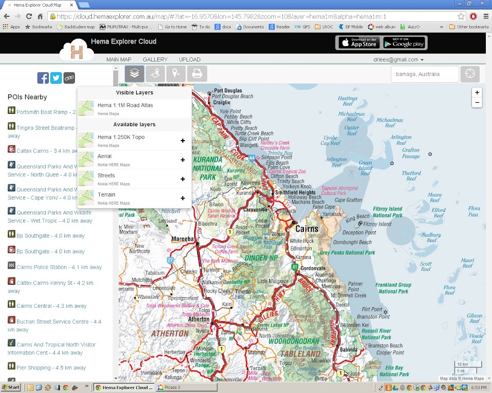
In the map area, sort out where you want to be and the best map scale and overlay for what you are doing.


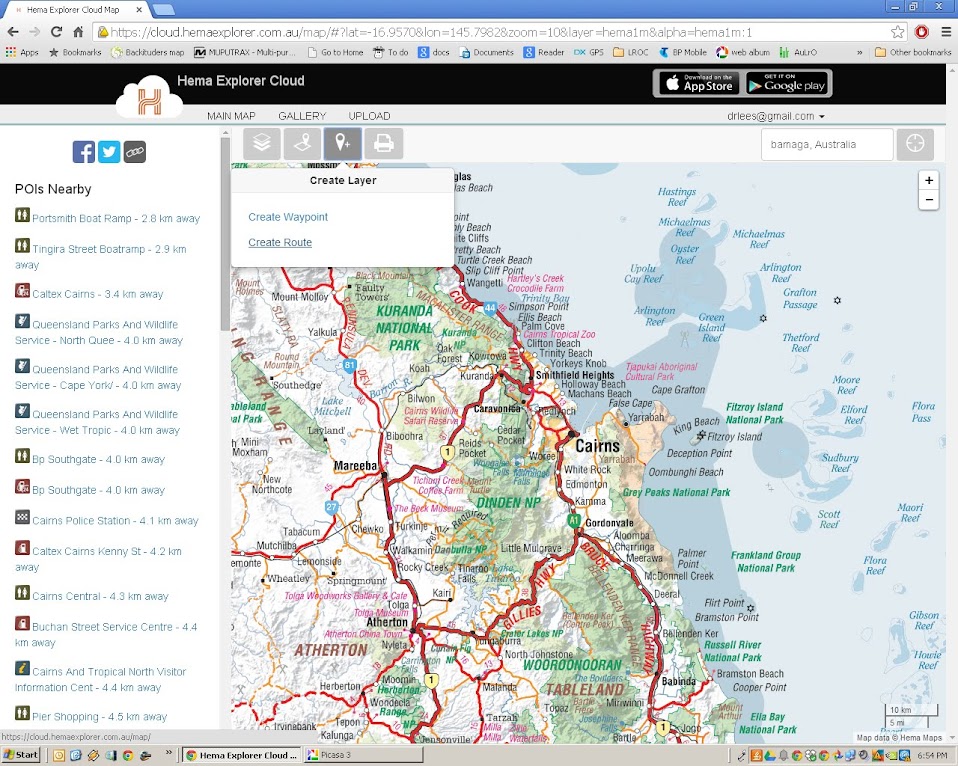
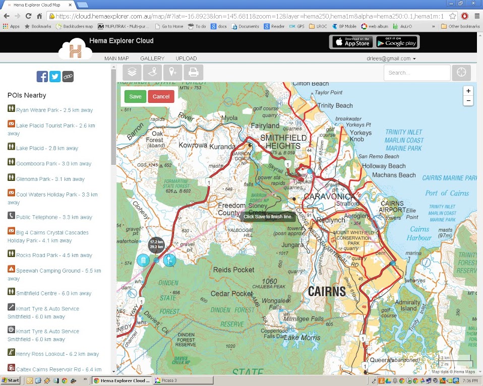
Select the route tool.


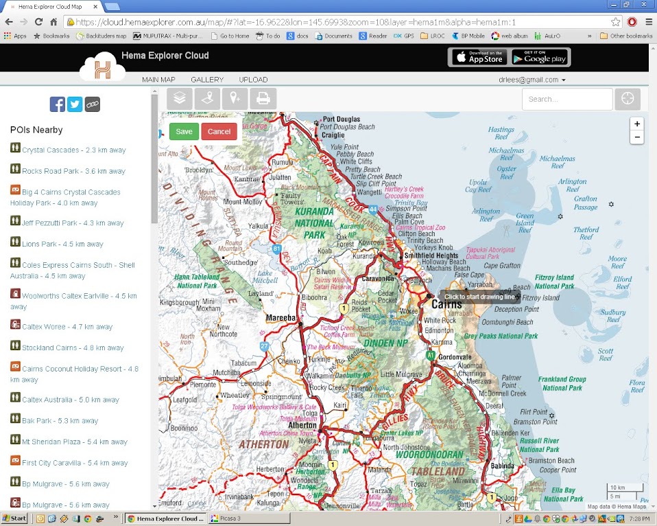
Click to start, and roughly work your way along the route you want to put in.


Don't put too much effort in at this stage, you can tune it later before you save it.


I'll keep this short, the principle is all we need to learn here.


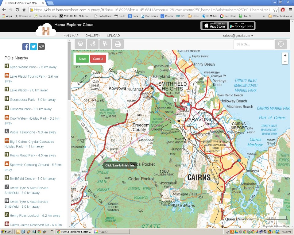
Notice the grey text box near an intermediate point? If you drag this to the road, it will create another intermediate point either side. This is where any fine tuning around tricky bits of track can be useful. Forget it for highways, they only need wide spacing.


Dragging the line.


You can see the new intermediate point near the grey text box.


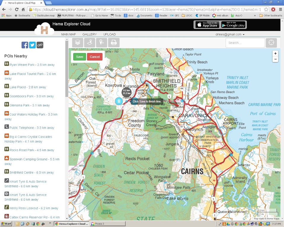
The intermediate point has become a main point on the road.

Beware of the Save button.
Once you save, you can no longer edit in the web browser.

Thus perhaps you may like to make several maps. One over view with very rough detail, just to show the whole track from start to finish.
You may want to make other routes for each day's travel with more detail.

Once you have your routes, you can share them (there is a link button to copy the link and paste it into an email (or forum) and others can see what you have planned
 
Now there seems to be no control over the colour of the line while laying out the route, so sorry if it is a bit hard to see, but once the route is saved you do have control, and can make it contrast against the map quite well.

This is a route I have planned out next time I'm up the East Coast of Tasmania.

Once you have done the trip, you can also up load tracks and photos to share with others.
This one is from a walk we did in the Flinders Ranges a month or so ago.

So you can see it is quite a versatile tool for recording and sharing proposed and past trips.

Cheers

Offline Jaysea

  • Soft Floor Camper User
  • ****
  • Posts: 543
  • Thanked: 31 times
  • Gender: Male
  • To go where I have never been
    • My 4WD Site
Re: map of travels
« Reply #10 on: July 09, 2015, 10:13:14 PM »
Wow - this is why this forum is so great.  Thanks for all of the replies.

http://maptag.com.au/ I was given one of the Cloth Maps of Australia. Black Background with white detail. i filled in our travels using a fine paint pen in a fluro colour. ........


Madcow - love the idea of something physical to look at - although not sure who can model the map of Tasi?

I have been lucky enough to record most of my trips over the years as plot (.plt) files in Oziexplorer.......
I purchased a large map of Australia which I stapled to a cork board........


Richard - that hard copy also looks amazing - man you have been to a huge number of places!!!


  using https://cloud.hemaexplorer.com.au is relatively simple.
It works best if you have a hema app on a phone as you can create routes on the pc and have them synch to the phone. So much easier than working on a small screen. .........


Austastar - A great description of using hemaexplorer.  I had a play but I am not sure how well it will cope with multiple trips - especially if i am ever luck enough to do as many as Andrew ;D

Just found this blog which details how to use a service called UMAP and openstreet map to upload GPS tracks AND more importantly, create a route in Google Maps and them import into UMAP
http://liferebooted.net/creating-route-maps-with-openstreetmap/


tkd421 - you are a legend   :cup: :cup:- this is exactly what i have been looking for.  I have just finished playing around with it and it works well.  I have only uploaded 2 maps from Google to Umap but it combined them without a problem.

While i am going to put them all digital i still like the traditional way so may buy a large map of Oz and put it on the wall as well

Thanks again to all the ideas.   :cheers: :cheers:
Jaysea

2012 Prado GXL + Adventure Camper

My build: http://www.myswag.org/index.php?topic=17776.0
My photos & travels: www.lensontheroad.com
My facebook: http://tinyurl.com/k2haolg


Offline tk421

  • Hard Floor Camper User
  • *****
  • Posts: 1050
  • Thanked: 108 times
  • Gender: Male
    • Out of the Office... Road trips round Australia
Re: map of travels
« Reply #11 on: January 06, 2016, 05:35:28 PM »
Its primitive, but I have a laminated Hema map of Australia in the pool room. I just use different colour paint pens to colour in the trip.

But for the trip video's I do, I download a high res map as a picture, and use Microsoft paint to draw in the trip.


Bit of an old thread but I've just discovered this piece of software...   http://www.routegenerator.net/

which lets you do stuff like this:
https://youtu.be/rgbQgldS5wg
“It is good to have an end to journey toward; but it is the journey that matters, in the end.”  - Ernest Hemingway